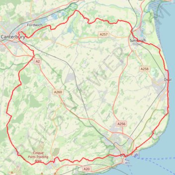
Coastal MTB loop from Canterbury in Kent Downs National Landscape
Mountain biking loop from Canterbury via Folkestone, Dover, Deal and Sandwich.
- Distance: 56.6 mi
- Elevation gain: 2,736 ft
- Maximum elevation: 610 ft
- Elevation loss: 2,713 ft
- Minimum elevation: 0 ft
- Moving time: 5 h 42 m
- Moving speed: 9.9 mph
- Maximum speed: 30.9 mph
- Total time: 6 h 33 m
- Global speed: 8.6 mph
Interactive trail map
Trail profile
- Distance: 56.6 mi
- Elevation gain: 2,736 ft
- Maximum elevation: 610 ft
- Elevation loss: 2,713 ft
- Minimum elevation: 0 ft
- Moving time: 5 h 42 m
- Moving speed: 9.9 mph
- Maximum speed: 30.9 mph
- Total time: 6 h 33 m
- Global speed: 8.6 mph
About this trail
Name: Coastal MTB loop from Canterbury in Kent Downs National Landscape trail, distance, elevation, map, profile, GPS track
Start: Military Road, Barracks, Canterbury, Kent, England, CT1 1JQ, United Kingdom (51.28530 1.09425)
End: Brymore Road, Barracks, Canterbury, Kent, England, CT1 1HP, United Kingdom (51.28557 1.09679)
Coordinates: 51.11243 1.06738 51.31395 1.40478
Other hiking, mountain biking, running and outdoor activity trails
Click on a trail to view its statistics, map and profile.
Walk around Canterbury area
United Kingdom > England > Kent > Canterbury
Distance: 5.8 mi • Elevation gain: 292 ft • Maximum elevation: 177 ft
Stodmarsh National Nature Reserve
United Kingdom > England > Kent > Canterbury > Wickhambreaux > Stodmarsh
Distance: 3.6 mi • Elevation gain: 43 ft • Maximum elevation: 20 ft