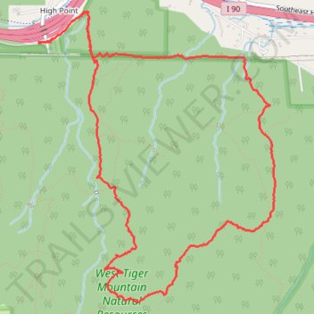
Loop hike from High Point Trailhead via Preston Trail Tiger Mountain Trail and High Point Trail
- Distance: 6.2 mi
- Elevation gain: 2,011 ft
- Maximum elevation: 2,208 ft
- Elevation loss: 2,005 ft
- Minimum elevation: 505 ft
- Moving time: 3 h 17 m
- Moving speed: 1.9 mph
- Maximum speed: 5.1 mph
- Total time: 3 h 27 m
- Global speed: 1.8 mph
Interactive trail map
Trail profile
- Distance: 6.2 mi
- Elevation gain: 2,011 ft
- Maximum elevation: 2,208 ft
- Elevation loss: 2,005 ft
- Minimum elevation: 505 ft
- Moving time: 3 h 17 m
- Moving speed: 1.9 mph
- Maximum speed: 5.1 mph
- Total time: 3 h 27 m
- Global speed: 1.8 mph
About this trail
Name: Loop hike from High Point Trailhead via Preston Trail Tiger Mountain Trail and High Point Trail trail, distance, elevation, map, profile, GPS track
Start: Southeast 79th Street, Issaquah, King County, Washington, 98029, United States (47.53045 -121.98046)
End: Southeast 79th Street, Issaquah, King County, Washington, 98029, United States (47.53035 -121.98051)
Coordinates: 47.51087 -121.98051 47.53268 -121.95417
Topography: King County topographic map, elevation, terrain
Other hiking, mountain biking, running and outdoor activity trails
Click on a trail to view its statistics, map and profile.
High Point Trail to West Tiger #2
United States > Washington > King County > Issaquah
Distance: 7.0 mi • Elevation gain: 2,365 ft • Maximum elevation: 2,703 ft
Northern part of the Pacific Crest Trail (PCT)
United States > Oregon > Klamath County
Hike on the Pacific Crest National Scenic Trail from Crater Lake to Canada Border through Oregon and Washington along the Sierra Nevada and Cascade mountain ranges. #Hiking #Mountain #SierraNevada #Cascade #Nature #Forest #Park #PCT
Distance: 744.6 mi • Elevation gain: 145,367 ft • Maximum elevation: 7,569 ft
Tiger Mountain - High point, K3, TMT and Section Line loop
United States > Washington > King County > Issaquah
Distance: 6.5 mi • Elevation gain: 2,238 ft • Maximum elevation: 2,602 ft