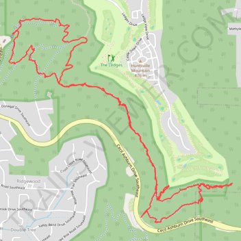
Jones Valley Loop, Bailey Cove, Fanning, Scout, and in-progress Bailey Cove extension trails
- Distance: 7.4 mi
- Elevation gain: 1,243 ft
- Maximum elevation: 1,378 ft
- Elevation loss: 1,243 ft
- Minimum elevation: 764 ft
- Moving time: 3 h 16 m
- Moving speed: 2.3 mph
- Maximum speed: 20.2 mph
- Total time: 3 h 28 m
- Global speed: 2.1 mph
Interactive trail map
Trail profile
- Distance: 7.4 mi
- Elevation gain: 1,243 ft
- Maximum elevation: 1,378 ft
- Elevation loss: 1,243 ft
- Minimum elevation: 764 ft
- Moving time: 3 h 16 m
- Moving speed: 2.3 mph
- Maximum speed: 20.2 mph
- Total time: 3 h 28 m
- Global speed: 2.1 mph
About this trail
Name: Jones Valley Loop, Bailey Cove, Fanning, Scout, and in-progress Bailey Cove extension trails trail, distance, elevation, map, profile, GPS track
Coordinates: 34.65761 -86.53061 34.67517 -86.50733
Topography: Huntsville topographic map, elevation, terrain
Other hiking, mountain biking, running and outdoor activity trails
Click on a trail to view its statistics, map and profile.
Fanning, Stevenson, Walsingham, Bailey Cove, and Jones Valley Loop trails
United States > Alabama > Madison County > Huntsville
Distance: 2.0 mi • Elevation gain: 469 ft • Maximum elevation: 1,220 ft
Loop hike via Jones Valley Loop, Bailey Cove, Walsingham, Fanning and unnamed trails in Blevins Preserve
United States > Alabama > Madison County > Huntsville
Distance: 3.8 mi • Elevation gain: 741 ft • Maximum elevation: 1,371 ft
Blevins Gap Nature Preserve loop
United States > Alabama > Madison County > Huntsville > Ridgewood
Distance: 8.3 mi • Elevation gain: 1,421 ft • Maximum elevation: 1,503 ft
Fanning Trail in Blevins Gap Preserve
United States > Alabama > Madison County > Huntsville > Huntsville Hills
Distance: 5.3 mi • Elevation gain: 951 ft • Maximum elevation: 1,342 ft
Green Mountain Loop Ride
United States > Alabama > Madison County > Huntsville > Willow Hills Estates
Distance: 31.4 mi • Elevation gain: 1,752 ft • Maximum elevation: 1,460 ft