Thank you for supporting this site ❤️
Make a donation
Make a donation
Gear up for your next adventure:
As an Amazon Associate, this site earns from qualifying purchases at no extra cost to you.
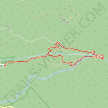
Badger Weir
- Distance: 2.5 mi
- Elevation gain: 427 ft
- Maximum elevation: 1,050 ft
- Elevation loss: 502 ft
- Minimum elevation: 702 ft
- Moving time: 45 m 46 s
- Moving speed: 3.3 mph
- Maximum speed: 10.0 mph
- Total time: 52 m 31 s
- Global speed: 2.8 mph
Interactive trail map
Thank you for supporting this site ❤️
Make a donation
Make a donation
Gear up for your next adventure:
As an Amazon Associate, this site earns from qualifying purchases at no extra cost to you.
Trail profile
- Distance: 2.5 mi
- Elevation gain: 427 ft
- Maximum elevation: 1,050 ft
- Elevation loss: 502 ft
- Minimum elevation: 702 ft
- Moving time: 45 m 46 s
- Moving speed: 3.3 mph
- Maximum speed: 10.0 mph
- Total time: 52 m 31 s
- Global speed: 2.8 mph
Thank you for supporting this site ❤️
Make a donation
Make a donation
Gear up for your next adventure:
As an Amazon Associate, this site earns from qualifying purchases at no extra cost to you.
About this trail
Name: Badger Weir trail, distance, elevation, map, profile, GPS track
Coordinates: -37.68700 145.56204 -37.68304 145.58269
Thank you for supporting this site ❤️
Make a donation
Make a donation
Gear up for your next adventure:
As an Amazon Associate, this site earns from qualifying purchases at no extra cost to you.
Other hiking, mountain biking, running and outdoor activity trails
Click on a trail to view its statistics, map and profile.
Tallarook - Eildon - Hurstbridge
Australia > Victoria > Tallarook
#Bike
Distance: 173.2 mi • Elevation gain: 16,066 ft • Maximum elevation: 2,848 ft