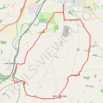
Derwent Kennythorpe Loop
- Distance: 9.9 mi
- Elevation gain: 633 ft
- Maximum elevation: 325 ft
- Elevation loss: 633 ft
- Minimum elevation: 62 ft
- Moving time: 2 h 5 m
- Moving speed: 4.7 mph
- Maximum speed: 7.5 mph
- Total time: 2 h 9 m
- Global speed: 4.6 mph
Interactive trail map
Trail profile
- Distance: 9.9 mi
- Elevation gain: 633 ft
- Maximum elevation: 325 ft
- Elevation loss: 633 ft
- Minimum elevation: 62 ft
- Moving time: 2 h 5 m
- Moving speed: 4.7 mph
- Maximum speed: 7.5 mph
- Total time: 2 h 9 m
- Global speed: 4.6 mph
About this trail
Name: Derwent Kennythorpe Loop trail, distance, elevation, map, profile, GPS track
Coordinates: 54.08228 -0.83375 54.12768 -0.77064
Other hiking, mountain biking, running and outdoor activity trails
Click on a trail to view its statistics, map and profile.
Settrington Beacon Loop from Norton-on-Derwent
United Kingdom > England > North Yorkshire > Norton-on-Derwent
Distance: 18.6 mi • Elevation gain: 1,352 ft • Maximum elevation: 659 ft
Appleton piggies
United Kingdom > England > North Yorkshire > Norton-on-Derwent
Distance: 23.4 mi • Elevation gain: 1,680 ft • Maximum elevation: 384 ft
North Grimston Loop from Norton-on-Derwent
United Kingdom > England > North Yorkshire > Malton
Distance: 13.3 mi • Elevation gain: 656 ft • Maximum elevation: 285 ft
Ryedale Trail Running
United Kingdom > England > North Yorkshire
Malton to Helmsley trot. #Running #Nature #Forest #Countryside
Distance: 18.6 mi • Elevation gain: 1,411 ft • Maximum elevation: 384 ft
Norton-on-Derwent south loop
United Kingdom > England > North Yorkshire > Norton-on-Derwent
Distance: 11.3 mi • Elevation gain: 810 ft • Maximum elevation: 325 ft
Norton to Langton loop
United Kingdom > England > North Yorkshire > Norton-on-Derwent
Ryedale Trail Running
Distance: 7.0 mi • Elevation gain: 666 ft • Maximum elevation: 325 ft
Norton-on-Derwent Loop
United Kingdom > England > North Yorkshire > Norton-on-Derwent
Distance: 6.2 mi • Elevation gain: 243 ft • Maximum elevation: 194 ft
Norton-on-Derwent Loop
United Kingdom > England > North Yorkshire > Norton-on-Derwent
Distance: 4.4 mi • Elevation gain: 138 ft • Maximum elevation: 141 ft
Westow out and back
United Kingdom > England > North Yorkshire > Burythorpe > Menethorpe
Distance: 5.0 mi • Elevation gain: 302 ft • Maximum elevation: 266 ft
Huttons Ambo loop
United Kingdom > England > North Yorkshire > Norton-on-Derwent
Distance: 6.5 mi • Elevation gain: 318 ft • Maximum elevation: 184 ft
Kennythorpe loop
United Kingdom > England > North Yorkshire > Norton-on-Derwent
Distance: 9.8 mi • Elevation gain: 610 ft • Maximum elevation: 325 ft
Aldro Farm loop
United Kingdom > England > North Yorkshire > Birdsall
Distance: 15.1 mi • Elevation gain: 1,135 ft • Maximum elevation: 778 ft
Low Hutton loop
United Kingdom > England > North Yorkshire > Norton-on-Derwent
Distance: 6.7 mi • Elevation gain: 338 ft • Maximum elevation: 184 ft
Menethorpe loop
United Kingdom > England > North Yorkshire > Norton-on-Derwent
Distance: 8.1 mi • Elevation gain: 531 ft • Maximum elevation: 315 ft
Derwent loop
United Kingdom > England > North Yorkshire > Norton-on-Derwent
Distance: 12.4 mi • Elevation gain: 751 ft • Maximum elevation: 315 ft
Malton Loop
United Kingdom > England > North Yorkshire > Norton-on-Derwent
Distance: 7.8 mi • Elevation gain: 390 ft • Maximum elevation: 256 ft
Acklam loop
United Kingdom > England > North Yorkshire > Norton-on-Derwent
Distance: 21.6 mi • Elevation gain: 1,808 ft • Maximum elevation: 778 ft
Hutton loop
United Kingdom > England > North Yorkshire > Norton-on-Derwent
Distance: 7.8 mi • Elevation gain: 295 ft • Maximum elevation: 184 ft