Thank you for supporting this site ❤️
Make a donation
Make a donation
Gear up for your next adventure:
As an Amazon Associate, this site earns from qualifying purchases at no extra cost to you.
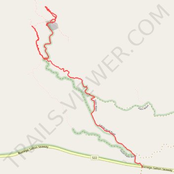
Calcite Mine Slot
- Distance: 3.4 mi
- Elevation gain: 499 ft
- Maximum elevation: 1,270 ft
- Elevation loss: 1,017 ft
- Minimum elevation: 538 ft
- Moving time: 1 h 20 m
- Moving speed: 2.5 mph
- Maximum speed: 11.1 mph
- Total time: 1 h 24 m
- Global speed: 2.4 mph
Interactive trail map
Thank you for supporting this site ❤️
Make a donation
Make a donation
Gear up for your next adventure:
As an Amazon Associate, this site earns from qualifying purchases at no extra cost to you.
Trail profile
- Distance: 3.4 mi
- Elevation gain: 499 ft
- Maximum elevation: 1,270 ft
- Elevation loss: 1,017 ft
- Minimum elevation: 538 ft
- Moving time: 1 h 20 m
- Moving speed: 2.5 mph
- Maximum speed: 11.1 mph
- Total time: 1 h 24 m
- Global speed: 2.4 mph
Thank you for supporting this site ❤️
Make a donation
Make a donation
Gear up for your next adventure:
As an Amazon Associate, this site earns from qualifying purchases at no extra cost to you.
About this trail
Name: Calcite Mine Slot trail, distance, elevation, map, profile, GPS track
Start: Calcite Mine Road, San Diego County, California, United States (33.29857 -116.11062)
End: Truckhaven Trail, San Diego County, California, United States (33.28086 -116.09635)
Coordinates: 33.28086 -116.11278 33.30088 -116.09631
Topography: San Diego County topographic map, elevation, terrain
Thank you for supporting this site ❤️
Make a donation
Make a donation
Gear up for your next adventure:
As an Amazon Associate, this site earns from qualifying purchases at no extra cost to you.