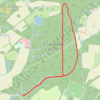
Loop Walk - St Leonards Forest
- Distance: 3.5 mi
- Elevation gain: 285 ft
- Maximum elevation: 427 ft
- Elevation loss: 285 ft
- Minimum elevation: 236 ft
- Moving time: 1 h 1 m
- Moving speed: 3.4 mph
- Maximum speed: 5.9 mph
- Total time: 1 h 12 m
- Global speed: 2.9 mph
Interactive trail map
Trail profile
- Distance: 3.5 mi
- Elevation gain: 285 ft
- Maximum elevation: 427 ft
- Elevation loss: 285 ft
- Minimum elevation: 236 ft
- Moving time: 1 h 1 m
- Moving speed: 3.4 mph
- Maximum speed: 5.9 mph
- Total time: 1 h 12 m
- Global speed: 2.9 mph
About this trail
Name: Loop Walk - St Leonards Forest trail, distance, elevation, map, profile, GPS track
Coordinates: 51.05498 -0.27762 51.07336 -0.26004
Other hiking, mountain biking, running and outdoor activity trails
Click on a trail to view its statistics, map and profile.
Walk - Slaugham, Furnace Pond, Lower Beeding
United Kingdom > England > West Sussex > Horsham
Distance: 10.7 mi • Elevation gain: 958 ft • Maximum elevation: 417 ft
Walk - Slaugham, Furnace Pond, Lower Beeding
United Kingdom > England > West Sussex > Mid Sussex > Slaugham
Distance: 10.7 mi • Elevation gain: 971 ft • Maximum elevation: 417 ft
Walk - Furnace Pond, Lower Beeding
United Kingdom > England > West Sussex > Mid Sussex > Slaugham
Distance: 11.0 mi • Elevation gain: 991 ft • Maximum elevation: 413 ft