Make a donation
Gear up for your next adventure:
As an Amazon Associate, this site earns from qualifying purchases at no extra cost to you.
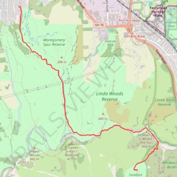
Steadfast reserve - summit
- Distance: 4.2 mi
- Elevation gain: 1,063 ft
- Maximum elevation: 1,398 ft
- Elevation loss: 1,362 ft
- Minimum elevation: 112 ft
- Moving time: 1 h 39 m
- Moving speed: 2.5 mph
- Maximum speed: 4.5 mph
- Total time: 1 h 54 m
- Global speed: 2.2 mph
Interactive trail map
Make a donation
Gear up for your next adventure:
As an Amazon Associate, this site earns from qualifying purchases at no extra cost to you.
Trail profile
- Distance: 4.2 mi
- Elevation gain: 1,063 ft
- Maximum elevation: 1,398 ft
- Elevation loss: 1,362 ft
- Minimum elevation: 112 ft
- Moving time: 1 h 39 m
- Moving speed: 2.5 mph
- Maximum speed: 4.5 mph
- Total time: 1 h 54 m
- Global speed: 2.2 mph
Make a donation
Gear up for your next adventure:
As an Amazon Associate, this site earns from qualifying purchases at no extra cost to you.
About this trail
Name: Steadfast reserve - summit trail, distance, elevation, map, profile, GPS track
Coordinates: -43.59860 172.66353 -43.56671 172.70095
Make a donation
Gear up for your next adventure:
As an Amazon Associate, this site earns from qualifying purchases at no extra cost to you.
Other hiking, mountain biking, running and outdoor activity trails
Click on a trail to view its statistics, map and profile.
Rapaki Track via MTB Singletrack
New Zealand > Canterbury > Christchurch City > Christchurch
Distance: 8.2 mi • Elevation gain: 1,312 ft • Maximum elevation: 1,089 ft
Afternoon Mountain Bike Ride
New Zealand > Christchurch City > Christchurch
Distance: 11.2 mi • Elevation gain: 1,480 ft • Maximum elevation: 1,089 ft