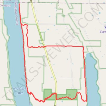
Hemlock DH
- Distance: 12.8 mi
- Elevation gain: 2,198 ft
- Maximum elevation: 1,772 ft
- Elevation loss: 2,205 ft
- Minimum elevation: 866 ft
Interactive trail map
Trail profile
- Distance: 12.8 mi
- Elevation gain: 2,198 ft
- Maximum elevation: 1,772 ft
- Elevation loss: 2,205 ft
- Minimum elevation: 866 ft
About this trail
Name: Hemlock DH trail, distance, elevation, map, profile, GPS track
End: Town of Canadice, Ontario County, New York, 14466, United States (42.76257 -77.61101)
Coordinates: 42.72023 -77.61126 42.76257 -77.57162
Topography: Ontario County topographic map, elevation, terrain