Thank you for supporting this site ❤️
Make a donation
Make a donation
Gear up for your next adventure:
As an Amazon Associate, this site earns from qualifying purchases at no extra cost to you.
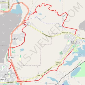
Side by Side ride around the Iron Range using the OHV Trails
- Distance: 14.1 mi
- Elevation gain: 886 ft
- Maximum elevation: 1,781 ft
- Elevation loss: 945 ft
- Minimum elevation: 1,480 ft
- Moving time: 1 h 14 m
- Moving speed: 11.3 mph
- Maximum speed: 38.0 mph
- Total time: 1 h 25 m
- Global speed: 9.9 mph
Interactive trail map
Thank you for supporting this site ❤️
Make a donation
Make a donation
Gear up for your next adventure:
As an Amazon Associate, this site earns from qualifying purchases at no extra cost to you.
Trail profile
- Distance: 14.1 mi
- Elevation gain: 886 ft
- Maximum elevation: 1,781 ft
- Elevation loss: 945 ft
- Minimum elevation: 1,480 ft
- Moving time: 1 h 14 m
- Moving speed: 11.3 mph
- Maximum speed: 38.0 mph
- Total time: 1 h 25 m
- Global speed: 9.9 mph
Thank you for supporting this site ❤️
Make a donation
Make a donation
Gear up for your next adventure:
As an Amazon Associate, this site earns from qualifying purchases at no extra cost to you.
About this trail
Name: Side by Side ride around the Iron Range using the OHV Trails trail, distance, elevation, map, profile, GPS track
Coordinates: 47.46111 -92.53320 47.51582 -92.46208
Topography: Saint Louis County topographic map, elevation, terrain
Thank you for supporting this site ❤️
Make a donation
Make a donation
Gear up for your next adventure:
As an Amazon Associate, this site earns from qualifying purchases at no extra cost to you.