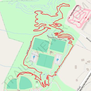
Mazeppa Park Loop
- Distance: 3.5 mi
- Elevation gain: 138 ft
- Maximum elevation: 889 ft
- Elevation loss: 138 ft
- Minimum elevation: 837 ft
- Moving time: 54 m 6 s
- Moving speed: 3.8 mph
- Maximum speed: 7.2 mph
- Total time: 58 m 44 s
- Global speed: 3.5 mph
Interactive trail map
Trail profile
- Distance: 3.5 mi
- Elevation gain: 138 ft
- Maximum elevation: 889 ft
- Elevation loss: 138 ft
- Minimum elevation: 837 ft
- Moving time: 54 m 6 s
- Moving speed: 3.8 mph
- Maximum speed: 7.2 mph
- Total time: 58 m 44 s
- Global speed: 3.5 mph
About this trail
Name: Mazeppa Park Loop trail, distance, elevation, map, profile, GPS track
Coordinates: 35.63451 -80.79790 35.64197 -80.79169
Topography: Iredell County topographic map, elevation, terrain
Other hiking, mountain biking, running and outdoor activity trails
Click on a trail to view its statistics, map and profile.
Mooresville Trail Run
United States > North Carolina > Iredell County > Mooresville
Distance: 4.4 mi • Elevation gain: 184 ft • Maximum elevation: 886 ft
Mazeppa Park Loop
United States > North Carolina > Iredell County > Mooresville
Mooresville Run
Distance: 2.6 mi • Elevation gain: 125 ft • Maximum elevation: 876 ft