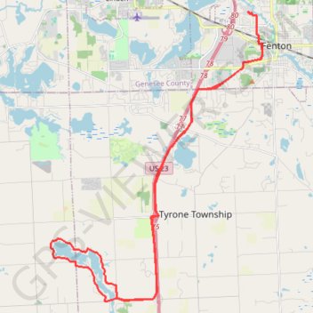
Lake Chanon Loop from Fenton
Fenton Road Cycling
- Distance: 25.3 mi
- Elevation gain: 1,079 ft
- Maximum elevation: 1,076 ft
- Elevation loss: 1,079 ft
- Minimum elevation: 886 ft
- Moving time: 1 h 38 m
- Moving speed: 15.4 mph
- Maximum speed: 33.4 mph
- Total time: 1 h 46 m
- Global speed: 14.3 mph
Interactive trail map
Trail profile
- Distance: 25.3 mi
- Elevation gain: 1,079 ft
- Maximum elevation: 1,076 ft
- Elevation loss: 1,079 ft
- Minimum elevation: 886 ft
- Moving time: 1 h 38 m
- Moving speed: 15.4 mph
- Maximum speed: 33.4 mph
- Total time: 1 h 46 m
- Global speed: 14.3 mph
About this trail
Name: Lake Chanon Loop from Fenton trail, distance, elevation, map, profile, GPS track
Coordinates: 42.70695 -83.81410 42.80982 -83.71175
Topography: Genesee County topographic map, elevation, terrain