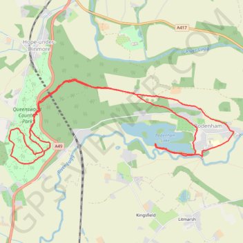
Queenswood Country Park loop and Bodenham Lake
Dinmore
- Distance: 7.3 mi
- Elevation gain: 627 ft
- Maximum elevation: 604 ft
- Elevation loss: 623 ft
- Minimum elevation: 194 ft
- Moving time: 2 h 57 m
- Moving speed: 2.5 mph
- Maximum speed: 5.6 mph
- Total time: 3 h 51 m
- Global speed: 1.9 mph
Interactive trail map
Trail profile
- Distance: 7.3 mi
- Elevation gain: 627 ft
- Maximum elevation: 604 ft
- Elevation loss: 623 ft
- Minimum elevation: 194 ft
- Moving time: 2 h 57 m
- Moving speed: 2.5 mph
- Maximum speed: 5.6 mph
- Total time: 3 h 51 m
- Global speed: 1.9 mph
About this trail
Name: Queenswood Country Park loop and Bodenham Lake trail, distance, elevation, map, profile, GPS track
Start: Queenswood, A49, Bodenham, Herefordshire, England, HR6 0PY, United Kingdom (52.15929 -2.72233)
End: Queenswood, A49, Bodenham, Herefordshire, England, HR6 0PY, United Kingdom (52.15915 -2.72262)
Coordinates: 52.15282 -2.72810 52.16340 -2.68228