Thank you for supporting this site ❤️
Make a donation
Make a donation
Gear up for your next adventure:
As an Amazon Associate, this site earns from qualifying purchases at no extra cost to you.
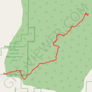
Sheep Mountain
- Distance: 11.4 mi
- Elevation gain: 1,713 ft
- Maximum elevation: 9,573 ft
- Elevation loss: 1,719 ft
- Minimum elevation: 8,186 ft
- Moving time: 4 h 5 m
- Moving speed: 2.8 mph
- Maximum speed: 4.7 mph
- Total time: 5 h 34 m
- Global speed: 2.0 mph
Interactive trail map
Thank you for supporting this site ❤️
Make a donation
Make a donation
Gear up for your next adventure:
As an Amazon Associate, this site earns from qualifying purchases at no extra cost to you.
Trail profile
- Distance: 11.4 mi
- Elevation gain: 1,713 ft
- Maximum elevation: 9,573 ft
- Elevation loss: 1,719 ft
- Minimum elevation: 8,186 ft
- Moving time: 4 h 5 m
- Moving speed: 2.8 mph
- Maximum speed: 4.7 mph
- Total time: 5 h 34 m
- Global speed: 2.0 mph
Thank you for supporting this site ❤️
Make a donation
Make a donation
Gear up for your next adventure:
As an Amazon Associate, this site earns from qualifying purchases at no extra cost to you.
About this trail
Name: Sheep Mountain trail, distance, elevation, map, profile, GPS track
Start: Fox Creek Road, Albany, Albany County, Wyoming, United States (41.17151 -106.06868)
End: Fox Creek Road, Albany, Albany County, Wyoming, United States (41.17145 -106.06825)
Coordinates: 41.16826 -106.06868 41.20474 -106.00741
Topography: Albany County topographic map, elevation, terrain
Thank you for supporting this site ❤️
Make a donation
Make a donation
Gear up for your next adventure:
As an Amazon Associate, this site earns from qualifying purchases at no extra cost to you.