Make a donation
Gear up for your next adventure:
As an Amazon Associate, this site earns from qualifying purchases at no extra cost to you.
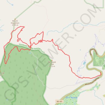
Third Creek Pond Loop via Tahoe Rim Trail in Humboldt-Toiyabe National Forest
The Third Creek Pond Loop via the Tahoe Rim Trail offers a picturesque hiking experience in the Humboldt-Toiyabe National Forest. This moderately challenging trail takes you through a variety of landscapes, from the serene Third Creek Pond to the surrounding pine forests, with occasional views of distant peaks. Along the route, hikers can enjoy peaceful, shaded stretches, gradual elevation changes, and the opportunity to observe local wildlife and alpine flora. #Hiking #Mountain #Forest #Nature #Lake #Loop
- Distance: 10.0 mi
- Elevation gain: 1,942 ft
- Maximum elevation: 10,125 ft
- Elevation loss: 1,942 ft
- Minimum elevation: 8,914 ft
Interactive trail map
Make a donation
Gear up for your next adventure:
As an Amazon Associate, this site earns from qualifying purchases at no extra cost to you.
Trail profile
- Distance: 10.0 mi
- Elevation gain: 1,942 ft
- Maximum elevation: 10,125 ft
- Elevation loss: 1,942 ft
- Minimum elevation: 8,914 ft
Make a donation
Gear up for your next adventure:
As an Amazon Associate, this site earns from qualifying purchases at no extra cost to you.
About this trail
Name: Third Creek Pond Loop via Tahoe Rim Trail in Humboldt-Toiyabe National Forest trail, distance, elevation, map, profile, GPS track
Start: Rest Stop to Relay, Washoe County, Nevada, United States (39.31392 -119.89773)
End: Mount Rose Highway, Washoe County, Nevada, United States (39.31390 -119.89770)
Coordinates: 39.31149 -119.94489 39.33122 -119.89735
Topography: Washoe County topographic map, elevation, terrain
Make a donation
Gear up for your next adventure:
As an Amazon Associate, this site earns from qualifying purchases at no extra cost to you.
Other hiking, mountain biking, running and outdoor activity trails
Click on a trail to view its statistics, map and profile.
Mount Rose via Tahoe Rim Trail and Rim to Rose in Humboldt-Toiyabe National Forest
United States > Nevada > Washoe County
Mount Rose via the Tahoe Rim Trail is a long and rewarding hike that gradually takes you through scenic meadows and past Galena Falls before reaching the final steep ascent. The climb to the summit is tough, but the sweeping views of Lake Tahoe and the surrounding peaks make it all worthwhile. It’s a perfect…
Distance: 11.3 mi • Elevation gain: 2,605 ft • Maximum elevation: 10,751 ft
Day 1: Home to dispersed camping 60 mi E of Austin, NV
United States > Nevada > Washoe County > Reno
Distance: 129.5 mi • Elevation gain: 3,320 ft • Maximum elevation: 5,128 ft