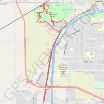
Rockport Park MTB
- Distance: 8.3 mi
- Elevation gain: 371 ft
- Maximum elevation: 863 ft
- Elevation loss: 371 ft
- Minimum elevation: 758 ft
- Moving time: 59 m 51 s
- Moving speed: 8.3 mph
- Maximum speed: 16.6 mph
- Total time: 1 h 2 m
- Global speed: 8.0 mph
Interactive trail map
Trail profile
- Distance: 8.3 mi
- Elevation gain: 371 ft
- Maximum elevation: 863 ft
- Elevation loss: 371 ft
- Minimum elevation: 758 ft
- Moving time: 59 m 51 s
- Moving speed: 8.3 mph
- Maximum speed: 16.6 mph
- Total time: 1 h 2 m
- Global speed: 8.0 mph
About this trail
Name: Rockport Park MTB trail, distance, elevation, map, profile, GPS track
Start: Peace Trail, Town of Rock, Rock County, Wisconsin, 53548, United States (42.63570 -89.06635)
End: Peace Trail, Town of Rock, Rock County, Wisconsin, 53548, United States (42.63568 -89.06633)
Coordinates: 42.63568 -89.07000 42.67119 -89.05478
Topography: Rock County topographic map, elevation, terrain
Other hiking, mountain biking, running and outdoor activity trails
Click on a trail to view its statistics, map and profile.
Rockport Park Loop MTB
United States > Wisconsin > Rock County > Janesville
Distance: 5.3 mi • Elevation gain: 377 ft • Maximum elevation: 860 ft