Thank you for supporting this site ❤️
Make a donation
Make a donation
Gear up for your next adventure:
As an Amazon Associate, this site earns from qualifying purchases at no extra cost to you.
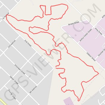
Parys wetlands loop
- Distance: 3.1 mi
- Elevation gain: 118 ft
- Maximum elevation: 4,629 ft
- Elevation loss: 118 ft
- Minimum elevation: 4,560 ft
- Moving time: 1 h 4 m
- Moving speed: 2.9 mph
- Maximum speed: 6.1 mph
- Total time: 1 h 4 m
- Global speed: 2.9 mph
Interactive trail map
Thank you for supporting this site ❤️
Make a donation
Make a donation
Gear up for your next adventure:
As an Amazon Associate, this site earns from qualifying purchases at no extra cost to you.
Trail profile
- Distance: 3.1 mi
- Elevation gain: 118 ft
- Maximum elevation: 4,629 ft
- Elevation loss: 118 ft
- Minimum elevation: 4,560 ft
- Moving time: 1 h 4 m
- Moving speed: 2.9 mph
- Maximum speed: 6.1 mph
- Total time: 1 h 4 m
- Global speed: 2.9 mph
Thank you for supporting this site ❤️
Make a donation
Make a donation
Gear up for your next adventure:
As an Amazon Associate, this site earns from qualifying purchases at no extra cost to you.
About this trail
Name: Parys wetlands loop trail, distance, elevation, map, profile, GPS track
Coordinates: -26.91866 27.45708 -26.90957 27.46684
Thank you for supporting this site ❤️
Make a donation
Make a donation
Gear up for your next adventure:
As an Amazon Associate, this site earns from qualifying purchases at no extra cost to you.