Make a donation
Gear up for your next adventure:
As an Amazon Associate, this site earns from qualifying purchases at no extra cost to you.
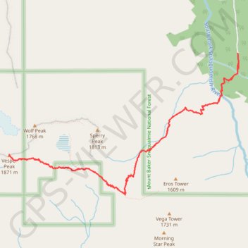
Vesper Peak via Sunrise Mine Trail in Mount Baker-Snoqualmie National Forest
The hike to Vesper Peak via the Sunrise Mine Trail offers a challenging and scenic adventure, where you'll experience a range of terrain types, from lush forests and expansive meadows to rocky slopes and boulder fields. As you climb, you'll be treated to panoramic views of surrounding peaks such as Morning Star Peak and Sperry Peak, with the highlight being the breathtaking vistas from the summit overlooking Copper Lake and the rugged North Cascades. The route, while demanding due to its steep sections and rocky scrambles, rewards hikers with a sense of solitude and a remarkable alpine experience. #Hiking #Mountain #Forest #Nature
- Distance: 6.8 mi
- Elevation gain: 4,065 ft
- Maximum elevation: 6,181 ft
- Elevation loss: 4,058 ft
- Minimum elevation: 2,283 ft
Interactive trail map
Make a donation
Gear up for your next adventure:
As an Amazon Associate, this site earns from qualifying purchases at no extra cost to you.
Trail profile
- Distance: 6.8 mi
- Elevation gain: 4,065 ft
- Maximum elevation: 6,181 ft
- Elevation loss: 4,058 ft
- Minimum elevation: 2,283 ft
Make a donation
Gear up for your next adventure:
As an Amazon Associate, this site earns from qualifying purchases at no extra cost to you.
About this trail
Name: Vesper Peak via Sunrise Mine Trail in Mount Baker-Snoqualmie National Forest trail, distance, elevation, map, profile, GPS track
End: Sunrise Mine Trail, Snohomish County, Washington, United States (48.02462 -121.47785)
Coordinates: 48.00829 -121.51798 48.02493 -121.47772
Topography: Snohomish County topographic map, elevation, terrain
Make a donation
Gear up for your next adventure:
As an Amazon Associate, this site earns from qualifying purchases at no extra cost to you.
Other hiking, mountain biking, running and outdoor activity trails
Click on a trail to view its statistics, map and profile.
Northern part of the Pacific Crest Trail (PCT)
United States > Oregon > Klamath County
Hike on the Pacific Crest National Scenic Trail from Crater Lake to Canada Border through Oregon and Washington along the Sierra Nevada and Cascade mountain ranges. #Hiking #Mountain #SierraNevada #Cascade #Nature #Forest #Park #PCT
Distance: 744.6 mi • Elevation gain: 145,367 ft • Maximum elevation: 7,569 ft