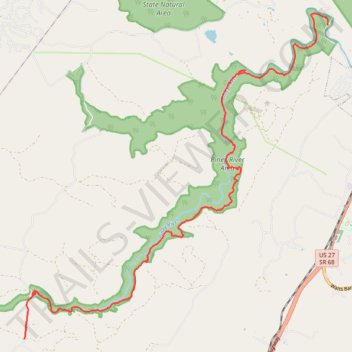
CT - Upper and Lower Piney River
- Distance: 12.8 mi
- Elevation gain: 1,657 ft
- Maximum elevation: 1,795 ft
- Elevation loss: 2,559 ft
- Minimum elevation: 889 ft
- Moving time: 6 h 17 m
- Moving speed: 2.0 mph
- Maximum speed: 4.6 mph
- Total time: 7 h 32 m
- Global speed: 1.7 mph
Interactive trail map
Trail profile
- Distance: 12.8 mi
- Elevation gain: 1,657 ft
- Maximum elevation: 1,795 ft
- Elevation loss: 2,559 ft
- Minimum elevation: 889 ft
- Moving time: 6 h 17 m
- Moving speed: 2.0 mph
- Maximum speed: 4.6 mph
- Total time: 7 h 32 m
- Global speed: 1.7 mph
About this trail
Name: CT - Upper and Lower Piney River trail, distance, elevation, map, profile, GPS track
Start: Pine Creek Road, Rhea County, East Tennessee, Tennessee, United States (35.63922 -84.96913)
End: Shut in Gap Road, Rhea County, East Tennessee, Tennessee, 37381, United States (35.71329 -84.88087)
Coordinates: 35.63919 -84.96913 35.71610 -84.88068
Topography: Rhea County topographic map, elevation, terrain
Other hiking, mountain biking, running and outdoor activity trails
Click on a trail to view its statistics, map and profile.
Cumberland Trail from Head of Sequatchie to Stinging Fork via Hinch Mountain
United States > Tennessee > Cumberland County
Distance: 17.5 mi • Elevation gain: 3,642 ft • Maximum elevation: 2,510 ft
CT - Stinging Fork to Pond Cove Creek Campsite via CT - Hinch Mountain
United States > Tennessee > Rhea County
Distance: 11.6 mi • Elevation gain: 2,133 ft • Maximum elevation: 2,507 ft
Twin Rocks Overlook in Piney River Area
United States > Tennessee > Rhea County
Distance: 2.0 mi • Elevation gain: 417 ft • Maximum elevation: 1,214 ft
Duskin Branch Trail
United States > Tennessee > Rhea County
Distance: 12.4 mi • Elevation gain: 1,952 ft • Maximum elevation: 1,722 ft