Thank you for supporting this site ❤️
Make a donation
Make a donation
Gear up for your next adventure:
As an Amazon Associate, this site earns from qualifying purchases at no extra cost to you.
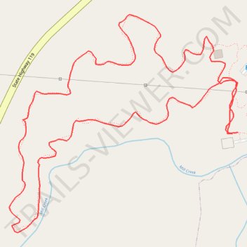
Forest Loop - Mebane
- Distance: 1.6 mi
- Elevation gain: 82 ft
- Maximum elevation: 610 ft
- Elevation loss: 85 ft
- Minimum elevation: 561 ft
- Moving time: 32 m 55 s
- Moving speed: 2.9 mph
- Maximum speed: 6.7 mph
- Total time: 32 m 55 s
- Global speed: 2.9 mph
Interactive trail map
Thank you for supporting this site ❤️
Make a donation
Make a donation
Gear up for your next adventure:
As an Amazon Associate, this site earns from qualifying purchases at no extra cost to you.
Trail profile
- Distance: 1.6 mi
- Elevation gain: 82 ft
- Maximum elevation: 610 ft
- Elevation loss: 85 ft
- Minimum elevation: 561 ft
- Moving time: 32 m 55 s
- Moving speed: 2.9 mph
- Maximum speed: 6.7 mph
- Total time: 32 m 55 s
- Global speed: 2.9 mph
Thank you for supporting this site ❤️
Make a donation
Make a donation
Gear up for your next adventure:
As an Amazon Associate, this site earns from qualifying purchases at no extra cost to you.
About this trail
Name: Forest Loop - Mebane trail, distance, elevation, map, profile, GPS track
Coordinates: 36.11606 -79.28085 36.12069 -79.27483
Topography: Alamance County topographic map, elevation, terrain
Thank you for supporting this site ❤️
Make a donation
Make a donation
Gear up for your next adventure:
As an Amazon Associate, this site earns from qualifying purchases at no extra cost to you.