Thank you for supporting this site ❤️
Make a donation
Make a donation
Gear up for your next adventure:
As an Amazon Associate, this site earns from qualifying purchases at no extra cost to you.
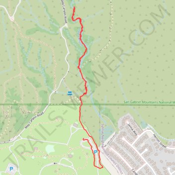
Loop Canyon - Angeles National Forest
- Distance: 1.4 mi
- Elevation gain: 279 ft
- Maximum elevation: 1,988 ft
- Elevation loss: 295 ft
- Minimum elevation: 1,722 ft
- Moving time: 44 m 57 s
- Moving speed: 1.9 mph
- Maximum speed: 4.0 mph
- Total time: 1 h 17 m
- Global speed: 1.1 mph
Interactive trail map
Thank you for supporting this site ❤️
Make a donation
Make a donation
Gear up for your next adventure:
As an Amazon Associate, this site earns from qualifying purchases at no extra cost to you.
Trail profile
- Distance: 1.4 mi
- Elevation gain: 279 ft
- Maximum elevation: 1,988 ft
- Elevation loss: 295 ft
- Minimum elevation: 1,722 ft
- Moving time: 44 m 57 s
- Moving speed: 1.9 mph
- Maximum speed: 4.0 mph
- Total time: 1 h 17 m
- Global speed: 1.1 mph
Thank you for supporting this site ❤️
Make a donation
Make a donation
Gear up for your next adventure:
As an Amazon Associate, this site earns from qualifying purchases at no extra cost to you.
About this trail
Name: Loop Canyon - Angeles National Forest trail, distance, elevation, map, profile, GPS track
Coordinates: 34.32638 -118.41542 34.33530 -118.41336
Topography: Los Angeles topographic map, elevation, terrain
Thank you for supporting this site ❤️
Make a donation
Make a donation
Gear up for your next adventure:
As an Amazon Associate, this site earns from qualifying purchases at no extra cost to you.