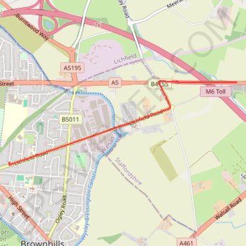
Lichfield Road to United Kingdom
- Distance: 1.7 mi
- Elevation gain: 23 ft
- Maximum elevation: 502 ft
- Elevation loss: 115 ft
- Minimum elevation: 407 ft
Interactive trail map
Trail profile
- Distance: 1.7 mi
- Elevation gain: 23 ft
- Maximum elevation: 502 ft
- Elevation loss: 115 ft
- Minimum elevation: 407 ft
About this trail
Name: Lichfield Road to United Kingdom trail, distance, elevation, map, profile, GPS track
Coordinates: 52.64906 -1.93194 52.65637 -1.89932
Other hiking, mountain biking, running and outdoor activity trails
Click on a trail to view its statistics, map and profile.
Chasewater Country Park circular all paths good
United Kingdom > England > Staffordshire > Lichfield > Burntwood > Chasetown
Distance: 8.2 mi • Elevation gain: 240 ft • Maximum elevation: 531 ft
Lichfield Road to Queen Mary's Grammar School
United Kingdom > England > Brownhills
Distance: 5.9 mi • Elevation gain: 151 ft • Maximum elevation: 505 ft
Lichfield Road to ALDI
United Kingdom > England > Brownhills
Distance: 0.2 mi • Elevation gain: 3 ft • Maximum elevation: 499 ft