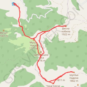
Besna kobila: od pl.doma na vrhove Musulj Čukar, Besna kobil...
- Distance: 11.8 mi
- Elevation gain: 3,081 ft
- Maximum elevation: 6,289 ft
- Elevation loss: 3,071 ft
- Minimum elevation: 4,767 ft
- Moving time: 5 h 45 m
- Moving speed: 2.0 mph
- Maximum speed: 3.7 mph
- Total time: 8 h 41 m
- Global speed: 1.4 mph
Interactive trail map
Trail profile
- Distance: 11.8 mi
- Elevation gain: 3,081 ft
- Maximum elevation: 6,289 ft
- Elevation loss: 3,071 ft
- Minimum elevation: 4,767 ft
- Moving time: 5 h 45 m
- Moving speed: 2.0 mph
- Maximum speed: 3.7 mph
- Total time: 8 h 41 m
- Global speed: 1.4 mph
About this trail
Name: Besna kobila: od pl.doma na vrhove Musulj Čukar, Besna kobil... trail, distance, elevation, map, profile, GPS track
Coordinates: 42.49971 22.19405 42.54108 22.23582
Other hiking, mountain biking, running and outdoor activity trails
Click on a trail to view its statistics, map and profile.
Besna Kobila (1923m)-Veliki Streser (1878m)-Topli Do hiking,...
Serbia > Central Serbia > Pcinja Administrative District > Vranjska Banja > Kriva Feja > Barje
Distance: 16.9 mi • Elevation gain: 3,501 ft • Maximum elevation: 6,257 ft
Trenutna trasa: 29 KOL 2015 09:15 001
Serbia > Central Serbia > Pcinja Administrative District > Vranjska Banja > Kriva Feja > Barje
Distance: 12.6 mi • Elevation gain: 3,094 ft • Maximum elevation: 6,263 ft