Thank you for supporting this site ❤️
Make a donation
Make a donation
Gear up for your next adventure:
As an Amazon Associate, this site earns from qualifying purchases at no extra cost to you.
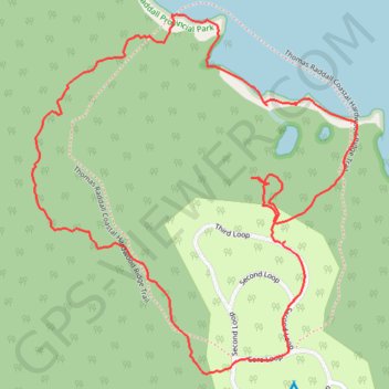
Coastal Hardwood Ridge Loop
#Hiking #Backcountry #Beach #Forest
- Distance: 1.9 mi
- Elevation gain: 105 ft
- Maximum elevation: 82 ft
- Elevation loss: 105 ft
- Minimum elevation: 0 ft
- Moving time: 59 m 32 s
- Moving speed: 1.9 mph
- Maximum speed: 3.5 mph
- Total time: 1 h 1 m
- Global speed: 1.8 mph
Interactive trail map
Thank you for supporting this site ❤️
Make a donation
Make a donation
Gear up for your next adventure:
As an Amazon Associate, this site earns from qualifying purchases at no extra cost to you.
Trail profile
- Distance: 1.9 mi
- Elevation gain: 105 ft
- Maximum elevation: 82 ft
- Elevation loss: 105 ft
- Minimum elevation: 0 ft
- Moving time: 59 m 32 s
- Moving speed: 1.9 mph
- Maximum speed: 3.5 mph
- Total time: 1 h 1 m
- Global speed: 1.8 mph
Thank you for supporting this site ❤️
Make a donation
Make a donation
Gear up for your next adventure:
As an Amazon Associate, this site earns from qualifying purchases at no extra cost to you.
About this trail
Name: Coastal Hardwood Ridge Loop trail, distance, elevation, map, profile, GPS track
Coordinates: 43.84373 -64.89203 43.85057 -64.88347
Thank you for supporting this site ❤️
Make a donation
Make a donation
Gear up for your next adventure:
As an Amazon Associate, this site earns from qualifying purchases at no extra cost to you.
Other hiking, mountain biking, running and outdoor activity trails
Click on a trail to view its statistics, map and profile.
Thomas Raddall Loop
Canada > Nova Scotia > Queens County > Port Joli
Hiking
Distance: 6.7 mi • Elevation gain: 335 ft • Maximum elevation: 144 ft