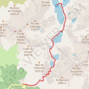
ACTIVE LOG
- Distance: 4.5 mi
- Elevation gain: 3,182 ft
- Maximum elevation: 7,205 ft
- Elevation loss: 318 ft
- Minimum elevation: 4,127 ft
- Moving time: 2 h 44 m
- Moving speed: 1.7 mph
- Maximum speed: 3.3 mph
- Total time: 2 h 45 m
- Global speed: 1.6 mph
Interactive trail map
Trail profile
- Distance: 4.5 mi
- Elevation gain: 3,182 ft
- Maximum elevation: 7,205 ft
- Elevation loss: 318 ft
- Minimum elevation: 4,127 ft
- Moving time: 2 h 44 m
- Moving speed: 1.7 mph
- Maximum speed: 3.3 mph
- Total time: 2 h 45 m
- Global speed: 1.6 mph
About this trail
Name: ACTIVE LOG trail, distance, elevation, map, profile, GPS track
Coordinates: 45.21050 6.05555 45.25017 6.08480
Other hiking, mountain biking, running and outdoor activity trails
Click on a trail to view its statistics, map and profile.
PT23DS2 Lörrach → Cadaqués
Germany > Baden-Württemberg > Landkreis Lörrach > Lörrach (Kernstadt)
Distance: 652.9 mi • Elevation gain: 43,077 ft • Maximum elevation: 4,938 ft
Chemin de Saint-Jacques-de-Compostelle
Switzerland > Geneva > Geneva
Distance: 694.6 mi • Elevation gain: 82,881 ft • Maximum elevation: 4,692 ft
Trail de l’Étendard - 44km
France > Auvergne-Rhône-Alpes > Isère > Le Bourg-d'Oisans > Le Bassey
Distance: 28.0 mi • Elevation gain: 10,367 ft • Maximum elevation: 8,944 ft