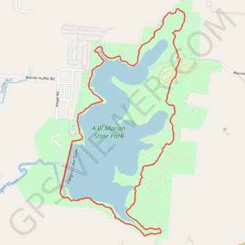
A. W. Marion State Park - Hargus Lake Perimeter Trail
- Distance: 3.9 mi
- Elevation gain: 292 ft
- Maximum elevation: 919 ft
- Elevation loss: 292 ft
- Minimum elevation: 807 ft
- Moving time: 1 h 12 m
- Moving speed: 3.3 mph
- Maximum speed: 7.5 mph
- Total time: 1 h 17 m
- Global speed: 3.0 mph
Interactive trail map
Trail profile
- Distance: 3.9 mi
- Elevation gain: 292 ft
- Maximum elevation: 919 ft
- Elevation loss: 292 ft
- Minimum elevation: 807 ft
- Moving time: 1 h 12 m
- Moving speed: 3.3 mph
- Maximum speed: 7.5 mph
- Total time: 1 h 17 m
- Global speed: 3.0 mph
About this trail
Name: A. W. Marion State Park - Hargus Lake Perimeter Trail trail, distance, elevation, map, profile, GPS track
Start: Mountain Bike Trail, Pickaway County, Ohio, 43154, United States (39.63458 -82.87555)
End: Hargus Lake Perimeter Trail, Pickaway County, Ohio, 43154, United States (39.63460 -82.87530)
Coordinates: 39.62112 -82.88718 39.63833 -82.87489
Topography: Pickaway County topographic map, elevation, terrain