Make a donation
Gear up for your next adventure:
As an Amazon Associate, this site earns from qualifying purchases at no extra cost to you.
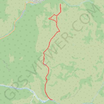
Little Cottonwood Trail
Hiking
- Distance: 6.9 mi
- Elevation gain: 1,171 ft
- Maximum elevation: 6,624 ft
- Elevation loss: 1,168 ft
- Minimum elevation: 5,518 ft
- Moving time: 2 h 18 m
- Moving speed: 3.0 mph
- Maximum speed: 5.2 mph
- Total time: 2 h 41 m
- Global speed: 2.6 mph
Interactive trail map
Make a donation
Gear up for your next adventure:
As an Amazon Associate, this site earns from qualifying purchases at no extra cost to you.
Trail profile
- Distance: 6.9 mi
- Elevation gain: 1,171 ft
- Maximum elevation: 6,624 ft
- Elevation loss: 1,168 ft
- Minimum elevation: 5,518 ft
- Moving time: 2 h 18 m
- Moving speed: 3.0 mph
- Maximum speed: 5.2 mph
- Total time: 2 h 41 m
- Global speed: 2.6 mph
Make a donation
Gear up for your next adventure:
As an Amazon Associate, this site earns from qualifying purchases at no extra cost to you.
About this trail
Name: Little Cottonwood Trail trail, distance, elevation, map, profile, GPS track
Start: Right Hand Fork Road, Cache County, Utah, United States (41.77492 -111.61011)
End: Right Hand Fork Road, Cache County, Utah, United States (41.77497 -111.61007)
Coordinates: 41.77489 -111.61525 41.81347 -111.60572
Topography: Cache County topographic map, elevation, terrain
Make a donation
Gear up for your next adventure:
As an Amazon Associate, this site earns from qualifying purchases at no extra cost to you.
Other hiking, mountain biking, running and outdoor activity trails
Click on a trail to view its statistics, map and profile.
Hiking Maughan Hollow
United States > Utah > Cache County
Distance: 5.5 mi • Elevation gain: 1,056 ft • Maximum elevation: 6,526 ft