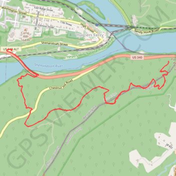
Split Rock via Loudoun Heights Trail in Harpers Ferry National Historical Park
Hiking the Split Rock via Loudoun Heights Trail offers a rewarding adventure through Harpers Ferry's natural beauty. The trail is strenuous, but hikers are rewarded with stunning views from Split Rock, where the Potomac and Shenandoah Rivers converge, and you can gaze across to Maryland Heights. With steep ascents and rugged terrain, it's a challenge best suited for prepared hikers, but the sweeping vistas and the quiet beauty of the surrounding forest make it a memorable trek. #Hiking #River #Forest #Nature #Rock
- Distance: 6.3 mi
- Elevation gain: 1,716 ft
- Maximum elevation: 1,066 ft
- Elevation loss: 1,716 ft
- Minimum elevation: 256 ft
- Moving time: 3 h 1 m
- Moving speed: 2.1 mph
- Maximum speed: 6.8 mph
- Total time: 3 h 18 m
- Global speed: 1.9 mph
Interactive trail map
Trail profile
- Distance: 6.3 mi
- Elevation gain: 1,716 ft
- Maximum elevation: 1,066 ft
- Elevation loss: 1,716 ft
- Minimum elevation: 256 ft
- Moving time: 3 h 1 m
- Moving speed: 2.1 mph
- Maximum speed: 6.8 mph
- Total time: 3 h 18 m
- Global speed: 1.9 mph
About this trail
Name: Split Rock via Loudoun Heights Trail in Harpers Ferry National Historical Park trail, distance, elevation, map, profile, GPS track
Coordinates: 39.31320 -77.74395 39.32182 -77.72054
Topography: Jefferson County topographic map, elevation, terrain