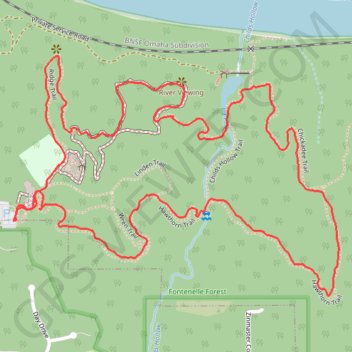
Loop hike in Fontenelle Forest via Hackberry Trail, Hawthorn Trail, Chickadee Trail, Riverview Boardwalk and Ridge Trail
This loop hike through Fontenelle Forest showcases a variety of scenic environments. Hikers can enjoy lush woodlands, open views of the Missouri River, and opportunities for wildlife observation, including various bird species. The well-maintained paths offer a mix of gentle slopes and boardwalks, making it accessible for all skill levels while immersing visitors in the tranquility of nature. #Hiking #Loop #Forest #River #Nature
- Distance: 2.5 mi
- Elevation gain: 397 ft
- Maximum elevation: 1,168 ft
- Elevation loss: 397 ft
- Minimum elevation: 1,017 ft
- Moving time: 1 h 4 m
- Moving speed: 2.3 mph
- Maximum speed: 5.4 mph
- Total time: 1 h 4 m
- Global speed: 2.3 mph
Interactive trail map
Trail profile
- Distance: 2.5 mi
- Elevation gain: 397 ft
- Maximum elevation: 1,168 ft
- Elevation loss: 397 ft
- Minimum elevation: 1,017 ft
- Moving time: 1 h 4 m
- Moving speed: 2.3 mph
- Maximum speed: 5.4 mph
- Total time: 1 h 4 m
- Global speed: 2.3 mph
About this trail
Name: Loop hike in Fontenelle Forest via Hackberry Trail, Hawthorn Trail, Chickadee Trail, Riverview Boardwalk and Ridge Trail trail, distance, elevation, map, profile, GPS track
Coordinates: 41.17765 -95.91826 41.18310 -95.90843
Topography: Bellevue topographic map, elevation, terrain
Other hiking, mountain biking, running and outdoor activity trails
Click on a trail to view its statistics, map and profile.
Bellevue Omaha Cycling
United States > Nebraska > Sarpy County > Bellevue
Distance: 28.1 mi • Elevation gain: 873 ft • Maximum elevation: 1,181 ft