Make a donation
Gear up for your next adventure:
As an Amazon Associate, this site earns from qualifying purchases at no extra cost to you.
The Window Trail in Big Bend National Park
The Window Trail is a delightful adventure that offers breathtaking views of the Chihuahuan Desert! As you descend through stunning rock formations and lush desert flora, the excitement builds until you reach the iconic Window Viewpoint, where the landscape opens up to magnificent vistas. The hike is a fantastic blend of beauty and challenge, especially on the return trip, which gets your heart pumping, but the reward of those views makes it all worthwhile! #Hiking #Mountain #Canyon #Desert #Nature
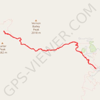
- Distance: 5.8 mi
- Elevation gain: 1,004 ft
- Maximum elevation: 5,397 ft
- Elevation loss: 1,004 ft
- Minimum elevation: 4,446 ft
- Moving time: 2 h 18 m
- Moving speed: 2.5 mph
- Maximum speed: 5.4 mph
- Total time: 2 h 50 m
- Global speed: 2.0 mph
Interactive trail map
Make a donation
Gear up for your next adventure:
As an Amazon Associate, this site earns from qualifying purchases at no extra cost to you.
Trail profile
- Distance: 5.8 mi
- Elevation gain: 1,004 ft
- Maximum elevation: 5,397 ft
- Elevation loss: 1,004 ft
- Minimum elevation: 4,446 ft
- Moving time: 2 h 18 m
- Moving speed: 2.5 mph
- Maximum speed: 5.4 mph
- Total time: 2 h 50 m
- Global speed: 2.0 mph
Make a donation
Gear up for your next adventure:
As an Amazon Associate, this site earns from qualifying purchases at no extra cost to you.
About this trail
Name: The Window Trail in Big Bend National Park trail, distance, elevation, map, profile, GPS track
Start: Window Trail, Brewster County, Texas, United States (29.27019 -103.30104)
End: Window Trail, Brewster County, Texas, United States (29.27023 -103.30107)
Coordinates: 29.27019 -103.33081 29.28085 -103.30104
Topography: Brewster County topographic map, elevation, terrain
Make a donation
Gear up for your next adventure:
As an Amazon Associate, this site earns from qualifying purchases at no extra cost to you.
Other hiking, mountain biking, running and outdoor activity trails
Click on a trail to view its statistics, map and profile.
Window Trail in Big Bend National Park
United States > Texas > Brewster County
The Window Trail in Big Bend National Park offers hikers a diverse journey through varied terrains, including desert landscapes, forested areas, and rocky paths. The trail culminates at a distinctive rock formation known as "The Window," providing expansive views of the Chihuahuan Desert below and distant…
Distance: 5.5 mi • Elevation gain: 942 ft • Maximum elevation: 5,384 ft
Emory Peak via Pinnacles Trail and Emory Peak Trail in Big Bend National Park
United States > Texas > Brewster County
If you're seeking an adventurous hike in Big Bend National Park, the route to Emory Peak is an excellent choice! This trail takes you through stunning landscapes, culminating in a rewarding scramble that leads to breathtaking 360-degree views from the summit. While the last stretch is steep and can be…
Distance: 10.2 mi • Elevation gain: 2,762 ft • Maximum elevation: 7,753 ft