Thank you for supporting this site ❤️
Make a donation
Make a donation
Gear up for your next adventure:
As an Amazon Associate, this site earns from qualifying purchases at no extra cost to you.
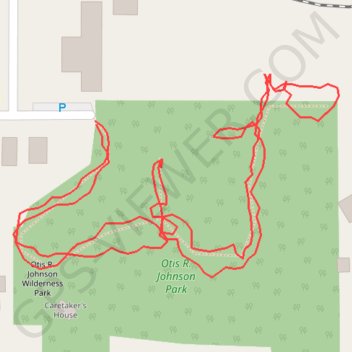
Otis R. Johnson Park
- Distance: 0.8 mi
- Elevation gain: 66 ft
- Maximum elevation: 135 ft
- Elevation loss: 66 ft
- Minimum elevation: 85 ft
- Moving time: 24 m
- Moving speed: 1.9 mph
- Maximum speed: 6.5 mph
- Total time: 27 m 6 s
- Global speed: 1.7 mph
Interactive trail map
Thank you for supporting this site ❤️
Make a donation
Make a donation
Gear up for your next adventure:
As an Amazon Associate, this site earns from qualifying purchases at no extra cost to you.
Trail profile
- Distance: 0.8 mi
- Elevation gain: 66 ft
- Maximum elevation: 135 ft
- Elevation loss: 66 ft
- Minimum elevation: 85 ft
- Moving time: 24 m
- Moving speed: 1.9 mph
- Maximum speed: 6.5 mph
- Total time: 27 m 6 s
- Global speed: 1.7 mph
Thank you for supporting this site ❤️
Make a donation
Make a donation
Gear up for your next adventure:
As an Amazon Associate, this site earns from qualifying purchases at no extra cost to you.
About this trail
Name: Otis R. Johnson Park trail, distance, elevation, map, profile, GPS track
Coordinates: 39.44454 -123.79550 39.44571 -123.79308
Topography: Mendocino County topographic map, elevation, terrain
Thank you for supporting this site ❤️
Make a donation
Make a donation
Gear up for your next adventure:
As an Amazon Associate, this site earns from qualifying purchases at no extra cost to you.