Www.ibpindex.com 36893301771388
www.ibpindex.com 36893301771388
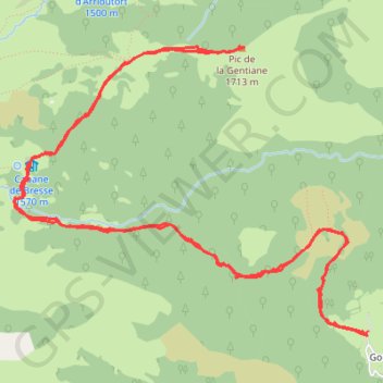
- Distance: 8.5 mi
- Elevation gain: 3,406 ft
- Maximum elevation: 5,709 ft
- Elevation loss: 3,406 ft
- Minimum elevation: 2,822 ft
- Moving time: 4 h 35 m
- Moving speed: 1.9 mph
- Maximum speed: 4.4 mph
- Total time: 6 h 22 m
- Global speed: 1.3 mph
Interactive trail map
Trail profile
- Distance: 8.5 mi
- Elevation gain: 3,406 ft
- Maximum elevation: 5,709 ft
- Elevation loss: 3,406 ft
- Minimum elevation: 2,822 ft
- Moving time: 4 h 35 m
- Moving speed: 1.9 mph
- Maximum speed: 4.4 mph
- Total time: 6 h 22 m
- Global speed: 1.3 mph
About this trail
Name: Www.ibpindex.com 36893301771388 trail, distance, elevation, map, profile, GPS track
Coordinates: 42.95139 -0.47975 42.97039 -0.44801
Other hiking, mountain biking, running and outdoor activity trails
Click on a trail to view its statistics, map and profile.
GR 10 - Traversée des Pyrénées
France > Occitania > Pyrénées-Orientales > Banyuls-sur-Mer
Distance: 543.6 mi • Elevation gain: 187,008 ft • Maximum elevation: 8,527 ft
1 LUCENA - MONTPELLIER
Distance: 1,842.0 mi • Elevation gain: 96,785 ft • Maximum elevation: 3,438 ft
Southern section — European Divide Trail
France > Auvergne-Rhône-Alpes > Drôme > Valence
Distance: 1,506.1 mi • Elevation gain: 139,026 ft • Maximum elevation: 6,578 ft