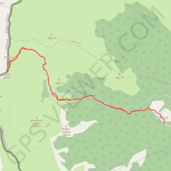
Peak Derza (2764masl.) - Korab
- Distance: 9.4 mi
- Elevation gain: 3,914 ft
- Maximum elevation: 7,753 ft
- Elevation loss: 3,914 ft
- Minimum elevation: 4,035 ft
- Moving time: 6 h 15 m
- Moving speed: 1.5 mph
- Maximum speed: 5.3 mph
- Total time: 9 h 22 m
- Global speed: 1.0 mph
Interactive trail map
Trail profile
- Distance: 9.4 mi
- Elevation gain: 3,914 ft
- Maximum elevation: 7,753 ft
- Elevation loss: 3,914 ft
- Minimum elevation: 4,035 ft
- Moving time: 6 h 15 m
- Moving speed: 1.5 mph
- Maximum speed: 5.3 mph
- Total time: 9 h 22 m
- Global speed: 1.0 mph
About this trail
Name: Peak Derza (2764masl.) - Korab trail, distance, elevation, map, profile, GPS track
Start: Tanushe, Municipality of Mavrovo and Rostusha, North Macedonia (41.72088 20.57294)
End: Tanushe, Municipality of Mavrovo and Rostusha, North Macedonia (41.72087 20.57297)
Coordinates: 41.72082 20.51863 41.74042 20.57326