Elkridge - Rockburn Branch Park Loop
- Distance: 2.7 mi
- Elevation gain: 157 ft
- Maximum elevation: 390 ft
- Elevation loss: 157 ft
- Minimum elevation: 305 ft
- Moving time: 32 m 38 s
- Moving speed: 4.9 mph
- Maximum speed: 10.6 mph
- Total time: 34 m 38 s
- Global speed: 4.7 mph
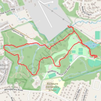
Interactive trail map
Trail profile
- Distance: 2.7 mi
- Elevation gain: 157 ft
- Maximum elevation: 390 ft
- Elevation loss: 157 ft
- Minimum elevation: 305 ft
- Moving time: 32 m 38 s
- Moving speed: 4.9 mph
- Maximum speed: 10.6 mph
- Total time: 34 m 38 s
- Global speed: 4.7 mph
About this trail
Name: Elkridge - Rockburn Branch Park Loop trail, distance, elevation, map, profile, GPS track
Start: Rockburn Trail, Columbia, Howard County, Maryland, 21075, United States (39.21845 -76.76126)
End: Rockburn Trail, Columbia, Howard County, Maryland, 21075, United States (39.21849 -76.76123)
Coordinates: 39.21634 -76.77589 39.22251 -76.76081
Topography: Columbia topographic map, elevation, terrain
Other hiking, mountain biking, running and outdoor activity trails
Click on a trail to view its statistics, map and profile.
Elkridge - Rockburn Branch Park
United States > Maryland > Howard County > Columbia
Distance: 2.9 mi • Elevation gain: 157 ft • Maximum elevation: 341 ft
Rockburn Branch Park Loop - Elkridge
United States > Maryland > Howard County > Columbia
Distance: 5.0 mi • Elevation gain: 272 ft • Maximum elevation: 367 ft