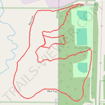
Rising Valley Park Red and Blue Trails Loop
- Distance: 2.1 mi
- Elevation gain: 289 ft
- Maximum elevation: 1,217 ft
- Elevation loss: 292 ft
- Minimum elevation: 1,070 ft
- Moving time: 45 m 26 s
- Moving speed: 2.8 mph
- Maximum speed: 4.4 mph
- Total time: 47 m 47 s
- Global speed: 2.7 mph
Interactive trail map
Trail profile
- Distance: 2.1 mi
- Elevation gain: 289 ft
- Maximum elevation: 1,217 ft
- Elevation loss: 292 ft
- Minimum elevation: 1,070 ft
- Moving time: 45 m 26 s
- Moving speed: 2.8 mph
- Maximum speed: 4.4 mph
- Total time: 47 m 47 s
- Global speed: 2.7 mph
About this trail
Name: Rising Valley Park Red and Blue Trails Loop trail, distance, elevation, map, profile, GPS track
Start: Blue Trail, Richfield Township, Summit County, Ohio, 44286, United States (41.26100 -81.68302)
End: Blue Trail, Richfield Township, Summit County, Ohio, 44286, United States (41.26111 -81.68336)
Coordinates: 41.25495 -81.68892 41.26111 -81.68232
Topography: Summit County topographic map, elevation, terrain