Thank you for supporting this site ❤️
Make a donation
Make a donation
Gear up for your next adventure:
As an Amazon Associate, this site earns from qualifying purchases at no extra cost to you.
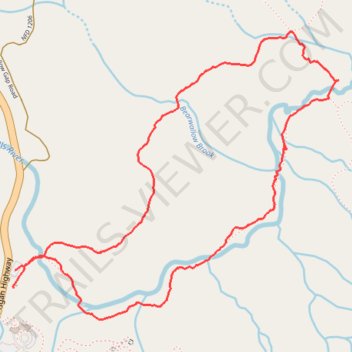
Pink Beds short loop in Pisgah National Forest
- Distance: 3.5 mi
- Elevation gain: 197 ft
- Maximum elevation: 3,304 ft
- Elevation loss: 187 ft
- Minimum elevation: 3,205 ft
- Moving time: 2 h 3 m
- Moving speed: 1.7 mph
- Maximum speed: 2.9 mph
- Total time: 2 h 55 m
- Global speed: 1.2 mph
Interactive trail map
Thank you for supporting this site ❤️
Make a donation
Make a donation
Gear up for your next adventure:
As an Amazon Associate, this site earns from qualifying purchases at no extra cost to you.
Trail profile
- Distance: 3.5 mi
- Elevation gain: 197 ft
- Maximum elevation: 3,304 ft
- Elevation loss: 187 ft
- Minimum elevation: 3,205 ft
- Moving time: 2 h 3 m
- Moving speed: 1.7 mph
- Maximum speed: 2.9 mph
- Total time: 2 h 55 m
- Global speed: 1.2 mph
Thank you for supporting this site ❤️
Make a donation
Make a donation
Gear up for your next adventure:
As an Amazon Associate, this site earns from qualifying purchases at no extra cost to you.
About this trail
Name: Pink Beds short loop in Pisgah National Forest trail, distance, elevation, map, profile, GPS track
Start: Pisgah Highway, Transylvania County, North Carolina, United States (35.35247 -82.77903)
Coordinates: 35.35105 -82.77907 35.36417 -82.76086
Topography: Transylvania County topographic map, elevation, terrain
Thank you for supporting this site ❤️
Make a donation
Make a donation
Gear up for your next adventure:
As an Amazon Associate, this site earns from qualifying purchases at no extra cost to you.