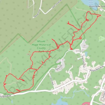
Mount Hope Historical County Park Loop
- Distance: 5.8 mi
- Elevation gain: 823 ft
- Maximum elevation: 1,060 ft
- Elevation loss: 823 ft
- Minimum elevation: 712 ft
- Moving time: 2 h 25 m
- Moving speed: 2.4 mph
- Maximum speed: 6.3 mph
- Total time: 3 h 16 m
- Global speed: 1.8 mph
Interactive trail map
Trail profile
- Distance: 5.8 mi
- Elevation gain: 823 ft
- Maximum elevation: 1,060 ft
- Elevation loss: 823 ft
- Minimum elevation: 712 ft
- Moving time: 2 h 25 m
- Moving speed: 2.4 mph
- Maximum speed: 6.3 mph
- Total time: 3 h 16 m
- Global speed: 1.8 mph
About this trail
Name: Mount Hope Historical County Park Loop trail, distance, elevation, map, profile, GPS track
Coordinates: 40.91379 -74.56807 40.92806 -74.54581
Topography: Morris County topographic map, elevation, terrain