Make a donation
Gear up for your next adventure:
As an Amazon Associate, this site earns from qualifying purchases at no extra cost to you.
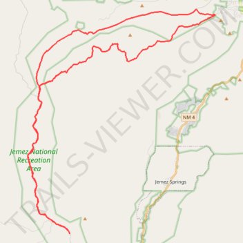
Schoolhouse Mesa, Lake Fork Canyon and Rio Guadalupe Loop Ride from Gilman tunnels in Jemez National Recreation Area
- Distance: 34.1 mi
- Elevation gain: 2,956 ft
- Maximum elevation: 8,645 ft
- Elevation loss: 2,953 ft
- Minimum elevation: 6,220 ft
- Moving time: 3 h 56 m
- Moving speed: 8.7 mph
- Maximum speed: 27.5 mph
- Total time: 5 h 44 m
- Global speed: 5.9 mph
Interactive trail map
Make a donation
Gear up for your next adventure:
As an Amazon Associate, this site earns from qualifying purchases at no extra cost to you.
Trail profile
- Distance: 34.1 mi
- Elevation gain: 2,956 ft
- Maximum elevation: 8,645 ft
- Elevation loss: 2,953 ft
- Minimum elevation: 6,220 ft
- Moving time: 3 h 56 m
- Moving speed: 8.7 mph
- Maximum speed: 27.5 mph
- Total time: 5 h 44 m
- Global speed: 5.9 mph
Make a donation
Gear up for your next adventure:
As an Amazon Associate, this site earns from qualifying purchases at no extra cost to you.
About this trail
Name: Schoolhouse Mesa, Lake Fork Canyon and Rio Guadalupe Loop Ride from Gilman tunnels in Jemez National Recreation Area trail, distance, elevation, map, profile, GPS track
Start: Lake Fork Canyon Road, Sandoval County, New Mexico, United States (35.73777 -106.76492)
End: Lake Fork Canyon Road, Sandoval County, New Mexico, United States (35.73773 -106.76494)
Coordinates: 35.73773 -106.79533 35.86956 -106.65987
Topography: Sandoval County topographic map, elevation, terrain
Make a donation
Gear up for your next adventure:
As an Amazon Associate, this site earns from qualifying purchases at no extra cost to you.
Other hiking, mountain biking, running and outdoor activity trails
Click on a trail to view its statistics, map and profile.
Alternative road to climb to top of 376
United States > New Mexico > Sandoval County
Distance: 36.6 mi • Elevation gain: 3,179 ft • Maximum elevation: 8,645 ft
Jemez MTB ride
United States > New Mexico > Sandoval County > O'Neil Landing
Lunch Mountain Bike Ride
Distance: 16.3 mi • Elevation gain: 2,828 ft • Maximum elevation: 9,049 ft