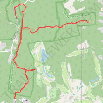
Hiking trails in Woody Hill Management Area
- Distance: 5.2 mi
- Elevation gain: 236 ft
- Maximum elevation: 184 ft
- Elevation loss: 236 ft
- Minimum elevation: 105 ft
- Moving time: 2 h 17 m
- Moving speed: 2.3 mph
- Maximum speed: 4.2 mph
- Total time: 2 h 27 m
- Global speed: 2.1 mph
Interactive trail map
Trail profile
- Distance: 5.2 mi
- Elevation gain: 236 ft
- Maximum elevation: 184 ft
- Elevation loss: 236 ft
- Minimum elevation: 105 ft
- Moving time: 2 h 17 m
- Moving speed: 2.3 mph
- Maximum speed: 4.2 mph
- Total time: 2 h 27 m
- Global speed: 2.1 mph
About this trail
Name: Hiking trails in Woody Hill Management Area trail, distance, elevation, map, profile, GPS track
Coordinates: 41.35619 -71.74559 41.37159 -71.72903
Topography: South County topographic map, elevation, terrain
Other hiking, mountain biking, running and outdoor activity trails
Click on a trail to view its statistics, map and profile.
Merged hiking and biking trails, Woody Hill Managament Area
United States > Rhode Island > South County > Westerly
Distance: 4.9 mi • Elevation gain: 282 ft • Maximum elevation: 210 ft