Thank you for supporting this site ❤️
Make a donation
Make a donation
Gear up for your next adventure:
As an Amazon Associate, this site earns from qualifying purchases at no extra cost to you.
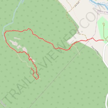
Granite Tors Walking Trail
- Distance: 3.1 mi
- Elevation gain: 23 ft
- Maximum elevation: 4,324 ft
- Elevation loss: 1,276 ft
- Minimum elevation: 3,058 ft
Interactive trail map
Thank you for supporting this site ❤️
Make a donation
Make a donation
Gear up for your next adventure:
As an Amazon Associate, this site earns from qualifying purchases at no extra cost to you.
Trail profile
- Distance: 3.1 mi
- Elevation gain: 23 ft
- Maximum elevation: 4,324 ft
- Elevation loss: 1,276 ft
- Minimum elevation: 3,058 ft
Thank you for supporting this site ❤️
Make a donation
Make a donation
Gear up for your next adventure:
As an Amazon Associate, this site earns from qualifying purchases at no extra cost to you.
About this trail
Name: Granite Tors Walking Trail trail, distance, elevation, map, profile, GPS track
Coordinates: -35.63652 148.93097 -35.62674 148.95473
Thank you for supporting this site ❤️
Make a donation
Make a donation
Gear up for your next adventure:
As an Amazon Associate, this site earns from qualifying purchases at no extra cost to you.
Other hiking, mountain biking, running and outdoor activity trails
Click on a trail to view its statistics, map and profile.
Cloudride24.FINAL
Distance: 639.3 mi • Elevation gain: 69,823 ft • Maximum elevation: 5,755 ft