Thank you for supporting this site ❤️
Make a donation
Make a donation
Gear up for your next adventure:
As an Amazon Associate, this site earns from qualifying purchases at no extra cost to you.
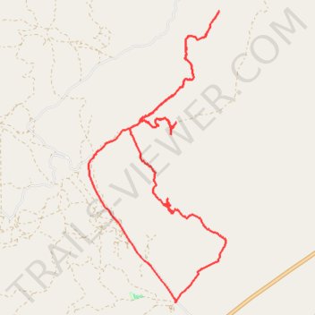
Eagle Mountain canyons
- Distance: 12.9 mi
- Elevation gain: 2,395 ft
- Maximum elevation: 6,260 ft
- Elevation loss: 2,398 ft
- Minimum elevation: 4,764 ft
- Moving time: 2 h 45 m
- Moving speed: 4.7 mph
- Maximum speed: 20.8 mph
- Total time: 3 h 24 m
- Global speed: 3.8 mph
Interactive trail map
Thank you for supporting this site ❤️
Make a donation
Make a donation
Gear up for your next adventure:
As an Amazon Associate, this site earns from qualifying purchases at no extra cost to you.
Trail profile
- Distance: 12.9 mi
- Elevation gain: 2,395 ft
- Maximum elevation: 6,260 ft
- Elevation loss: 2,398 ft
- Minimum elevation: 4,764 ft
- Moving time: 2 h 45 m
- Moving speed: 4.7 mph
- Maximum speed: 20.8 mph
- Total time: 3 h 24 m
- Global speed: 3.8 mph
Thank you for supporting this site ❤️
Make a donation
Make a donation
Gear up for your next adventure:
As an Amazon Associate, this site earns from qualifying purchases at no extra cost to you.
About this trail
Name: Eagle Mountain canyons trail, distance, elevation, map, profile, GPS track
Start: Soldiers Pass Road, Utah County, Utah, United States (40.17397 -111.94550)
End: Soldiers Pass Road, Utah County, Utah, United States (40.17378 -111.94558)
Coordinates: 40.17378 -111.96572 40.22529 -111.93391
Topography: Utah County topographic map, elevation, terrain
Thank you for supporting this site ❤️
Make a donation
Make a donation
Gear up for your next adventure:
As an Amazon Associate, this site earns from qualifying purchases at no extra cost to you.