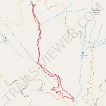
Twin Falls hike
- Distance: 4.8 mi
- Elevation gain: 879 ft
- Maximum elevation: 3,005 ft
- Elevation loss: 883 ft
- Minimum elevation: 2,493 ft
- Moving time: 2 h 16 m
- Moving speed: 2.1 mph
- Maximum speed: 4.1 mph
- Total time: 4 h 4 m
- Global speed: 1.2 mph
Interactive trail map
Trail profile
- Distance: 4.8 mi
- Elevation gain: 879 ft
- Maximum elevation: 3,005 ft
- Elevation loss: 883 ft
- Minimum elevation: 2,493 ft
- Moving time: 2 h 16 m
- Moving speed: 2.1 mph
- Maximum speed: 4.1 mph
- Total time: 4 h 4 m
- Global speed: 1.2 mph
About this trail
Name: Twin Falls hike trail, distance, elevation, map, profile, GPS track
Start: Avery Creek Road, Transylvania County, North Carolina, United States (35.31488 -82.74918)
End: Avery Creek Road, Transylvania County, North Carolina, United States (35.31479 -82.74915)
Coordinates: 35.31479 -82.76028 35.33640 -82.74890
Topography: Transylvania County topographic map, elevation, terrain