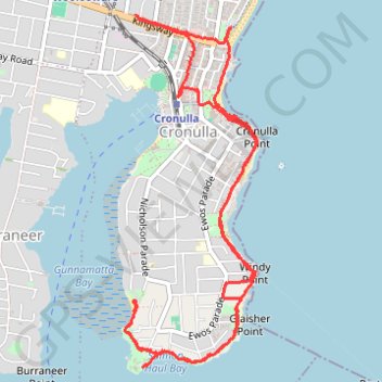
Sydney Hike
- Distance: 6.5 mi
- Elevation gain: 476 ft
- Maximum elevation: 85 ft
- Elevation loss: 466 ft
- Minimum elevation: 0 ft
- Moving time: 2 h 6 m
- Moving speed: 3.1 mph
- Maximum speed: 6.7 mph
- Total time: 2 h 33 m
- Global speed: 2.5 mph
Interactive trail map
Trail profile
- Distance: 6.5 mi
- Elevation gain: 476 ft
- Maximum elevation: 85 ft
- Elevation loss: 466 ft
- Minimum elevation: 0 ft
- Moving time: 2 h 6 m
- Moving speed: 3.1 mph
- Maximum speed: 6.7 mph
- Total time: 2 h 33 m
- Global speed: 2.5 mph
About this trail
Name: Sydney Hike trail, distance, elevation, map, profile, GPS track
Coordinates: -34.07334 151.14727 -34.04971 151.15801
Other hiking, mountain biking, running and outdoor activity trails
Click on a trail to view its statistics, map and profile.
Cronulla Park
Australia > New South Wales > Sydney
Sydney Trail Run
Distance: 5.3 mi • Elevation gain: 279 ft • Maximum elevation: 108 ft