Thank you for supporting this site ❤️
Make a donation
Make a donation
Gear up for your next adventure:
As an Amazon Associate, this site earns from qualifying purchases at no extra cost to you.
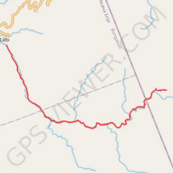
Labi Trail
File with points/tracks from Locus Map/4.24.3
- Distance: 6.7 mi
- Elevation gain: 909 ft
- Maximum elevation: 2,867 ft
- Elevation loss: 2,894 ft
- Minimum elevation: 873 ft
- Moving time: 3 h 32 m
- Moving speed: 1.9 mph
- Maximum speed: 4.6 mph
- Total time: 20 h 30 m
- Global speed: 0.3 mph
Interactive trail map
Thank you for supporting this site ❤️
Make a donation
Make a donation
Gear up for your next adventure:
As an Amazon Associate, this site earns from qualifying purchases at no extra cost to you.
Trail profile
- Distance: 6.7 mi
- Elevation gain: 909 ft
- Maximum elevation: 2,867 ft
- Elevation loss: 2,894 ft
- Minimum elevation: 873 ft
- Moving time: 3 h 32 m
- Moving speed: 1.9 mph
- Maximum speed: 4.6 mph
- Total time: 20 h 30 m
- Global speed: 0.3 mph
Thank you for supporting this site ❤️
Make a donation
Make a donation
Gear up for your next adventure:
As an Amazon Associate, this site earns from qualifying purchases at no extra cost to you.
About this trail
Name: Labi Trail trail, distance, elevation, map, profile, GPS track
Start: Aurora, Central Luzon, Philippines (15.62568 121.32947)
End: Labi, Bongabon, Nueva Ecija, Central Luzon, 3128, Philippines (15.64225 121.26876)
Coordinates: 15.61178 121.26870 15.64225 121.32949
Thank you for supporting this site ❤️
Make a donation
Make a donation
Gear up for your next adventure:
As an Amazon Associate, this site earns from qualifying purchases at no extra cost to you.