長情坑 石岩頭坑 花榕左 雷花
Hong Kong Hike
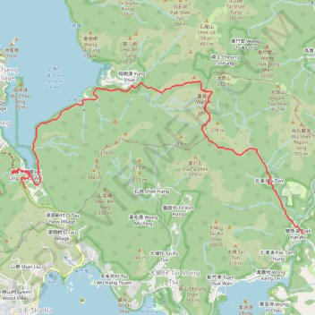
- Distance: 7.0 mi
- Elevation gain: 1,535 ft
- Maximum elevation: 1,184 ft
- Elevation loss: 1,706 ft
- Minimum elevation: 13 ft
- Moving time: 3 h 19 m
- Moving speed: 2.1 mph
- Maximum speed: 17.5 mph
- Total time: 5 h 2 m
- Global speed: 1.4 mph
Interactive trail map
Trail profile
- Distance: 7.0 mi
- Elevation gain: 1,535 ft
- Maximum elevation: 1,184 ft
- Elevation loss: 1,706 ft
- Minimum elevation: 13 ft
- Moving time: 3 h 19 m
- Moving speed: 2.1 mph
- Maximum speed: 17.5 mph
- Total time: 5 h 2 m
- Global speed: 1.4 mph
About this trail
Name: 長情坑 石岩頭坑 花榕左 雷花 trail, distance, elevation, map, profile, GPS track
Coordinates: 22.40093 114.27171 22.42595 114.32373
Other hiking, mountain biking, running and outdoor activity trails
Click on a trail to view its statistics, map and profile.
石深右坑 石榕左坑 石榕坑 猴塘溪 土瓜坪坑
China > Hong Kong > Tai Po District > Lai Chi Chong
Hong Kong Hike
Distance: 8.2 mi • Elevation gain: 2,326 ft • Maximum elevation: 1,198 ft
城門~北潭坳
China > Hong Kong > Tsuen Wan District > Kwai Chung > Lower Shing Mun Village
ShingMunReservoir~PakTamAu
Distance: 23.3 mi • Elevation gain: 7,156 ft • Maximum elevation: 1,808 ft
田尾下源 橫頭墩北坑 田鹿石澗左 蛇地 秋楓
China > Hong Kong > Sai Kung District > Tsak Yue Wu
Distance: 13.1 mi • Elevation gain: 2,661 ft • Maximum elevation: 1,102 ft
鯽魚湖南坑 雷花石澗 坪輋西坑
China > Hong Kong > Sai Kung District
Hong Kong Hike
Distance: 6.9 mi • Elevation gain: 2,316 ft • Maximum elevation: 1,201 ft
6月西貢海鮮🦞團
China > Hong Kong > Sha Tin District > Tai Shui Hang Village
Distance: 6.2 mi • Elevation gain: 1,460 ft • Maximum elevation: 1,312 ft
鯽魚湖西坑 蛇地坑 牌額西坑右源
China > Hong Kong > Sai Kung District > Tsak Yue Wu
Outdoor hiking
Distance: 7.0 mi • Elevation gain: 2,005 ft • Maximum elevation: 1,014 ft
東牛耳石坑 牛耳石坑 畫眉坑 雷榕石澗 畫眉西右坑 隱龍右源
China > Hong Kong > Tai Po District > Pak Tam Au
Hong Kong Hike
Distance: 8.4 mi • Elevation gain: 3,822 ft • Maximum elevation: 1,332 ft
長情左坑 彎曲北坑 獅尾坑
China > Hong Kong > Tai Po District > Sai Keng Village > Kei Ling Ha Lo Wai
Hong Kong Hike
Distance: 11.1 mi • Elevation gain: 3,642 ft • Maximum elevation: 1,860 ft
昂窝村
China > Hong Kong > Tai Po District > Sai Keng Village > Kei Ling Ha Lo Wai
Distance: 3.2 mi • Elevation gain: 801 ft • Maximum elevation: 997 ft
麦理浩径
China > Hong Kong > Sai Kung District > Tsak Yue Wu
北潭涌至屯门
Distance: 61.3 mi • Elevation gain: 16,886 ft • Maximum elevation: 3,031 ft