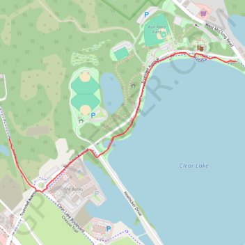
Clear Lake Greenway in Fox Memorial Park
- Distance: 0.9 mi
- Elevation gain: 33 ft
- Maximum elevation: 823 ft
- Elevation loss: 33 ft
- Minimum elevation: 804 ft
- Moving time: 16 m 25 s
- Moving speed: 3.3 mph
- Maximum speed: 4.2 mph
- Total time: 16 m 25 s
- Global speed: 3.3 mph
Interactive trail map
Trail profile
- Distance: 0.9 mi
- Elevation gain: 33 ft
- Maximum elevation: 823 ft
- Elevation loss: 33 ft
- Minimum elevation: 804 ft
- Moving time: 16 m 25 s
- Moving speed: 3.3 mph
- Maximum speed: 4.2 mph
- Total time: 16 m 25 s
- Global speed: 3.3 mph
About this trail
Name: Clear Lake Greenway in Fox Memorial Park trail, distance, elevation, map, profile, GPS track
Start: Truesdell Avenue, La Porte, LaPorte County, Indiana, 46350, United States (41.62381 -86.72008)
End: Chessie Trail, La Porte, LaPorte County, Indiana, 46350, United States (41.62089 -86.73147)
Coordinates: 41.61890 -86.73147 41.62412 -86.72008
Topography: LaPorte County topographic map, elevation, terrain
Other hiking, mountain biking, running and outdoor activity trails
Click on a trail to view its statistics, map and profile.
New Bike lanes and construction in La Porte
United States > Indiana > LaPorte County > La Porte
Distance: 18.7 mi • Elevation gain: 469 ft • Maximum elevation: 856 ft