Thank you for supporting this site ❤️
Make a donation
Make a donation
Gear up for your next adventure:
As an Amazon Associate, this site earns from qualifying purchases at no extra cost to you.
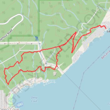
Cove Forest Hike
North Vancouver District Hiking
- Distance: 5.2 mi
- Elevation gain: 1,411 ft
- Maximum elevation: 705 ft
- Elevation loss: 1,430 ft
- Minimum elevation: 16 ft
- Moving time: 2 h 13 m
- Moving speed: 2.3 mph
- Maximum speed: 4.0 mph
- Total time: 2 h 21 m
- Global speed: 2.2 mph
Interactive trail map
Thank you for supporting this site ❤️
Make a donation
Make a donation
Gear up for your next adventure:
As an Amazon Associate, this site earns from qualifying purchases at no extra cost to you.
Trail profile
- Distance: 5.2 mi
- Elevation gain: 1,411 ft
- Maximum elevation: 705 ft
- Elevation loss: 1,430 ft
- Minimum elevation: 16 ft
- Moving time: 2 h 13 m
- Moving speed: 2.3 mph
- Maximum speed: 4.0 mph
- Total time: 2 h 21 m
- Global speed: 2.2 mph
Thank you for supporting this site ❤️
Make a donation
Make a donation
Gear up for your next adventure:
As an Amazon Associate, this site earns from qualifying purchases at no extra cost to you.
About this trail
Name: Cove Forest Hike trail, distance, elevation, map, profile, GPS track
Coordinates: 49.33150 -122.95167 49.34289 -122.92155
Thank you for supporting this site ❤️
Make a donation
Make a donation
Gear up for your next adventure:
As an Amazon Associate, this site earns from qualifying purchases at no extra cost to you.
Other hiking, mountain biking, running and outdoor activity trails
Click on a trail to view its statistics, map and profile.