Thank you for supporting this site ❤️
Make a donation
Make a donation
Gear up for your next adventure:
As an Amazon Associate, this site earns from qualifying purchases at no extra cost to you.
The Lake
Foot
- Distance: 0.9 mi
- Elevation gain: 49 ft
- Maximum elevation: 105 ft
- Elevation loss: 46 ft
- Minimum elevation: 59 ft
- Moving time: 18 m 55 s
- Moving speed: 2.8 mph
- Maximum speed: 4.1 mph
- Total time: 23 m 38 s
- Global speed: 2.2 mph
Interactive trail map
Thank you for supporting this site ❤️
Make a donation
Make a donation
Gear up for your next adventure:
As an Amazon Associate, this site earns from qualifying purchases at no extra cost to you.
Trail profile
- Distance: 0.9 mi
- Elevation gain: 49 ft
- Maximum elevation: 105 ft
- Elevation loss: 46 ft
- Minimum elevation: 59 ft
- Moving time: 18 m 55 s
- Moving speed: 2.8 mph
- Maximum speed: 4.1 mph
- Total time: 23 m 38 s
- Global speed: 2.2 mph
Thank you for supporting this site ❤️
Make a donation
Make a donation
Gear up for your next adventure:
As an Amazon Associate, this site earns from qualifying purchases at no extra cost to you.
About this trail
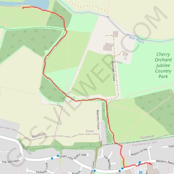
Name: The Lake trail, distance, elevation, map, profile, GPS track
Coordinates: 51.57123 0.66239 51.57818 0.67133
Thank you for supporting this site ❤️
Make a donation
Make a donation
Gear up for your next adventure:
As an Amazon Associate, this site earns from qualifying purchases at no extra cost to you.
Other hiking, mountain biking, running and outdoor activity trails
Click on a trail to view its statistics, map and profile.
Edward's Hall Park - The Lake
United Kingdom > England > Essex > Rochford
Foot
Distance: 0.9 mi • Elevation gain: 13 ft • Maximum elevation: 144 ft