Make a donation
Gear up for your next adventure:
As an Amazon Associate, this site earns from qualifying purchases at no extra cost to you.
Hillwalk Scafell Pike
Hillwalk, Scafell, Pike, Sca, Fell
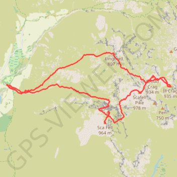
- Distance: 8.6 mi
- Elevation gain: 4,606 ft
- Maximum elevation: 3,182 ft
- Elevation loss: 4,610 ft
- Minimum elevation: 240 ft
- Moving time: 5 h 35 m
- Moving speed: 1.5 mph
- Maximum speed: 4.1 mph
- Total time: 6 h 51 m
- Global speed: 1.3 mph
Interactive trail map
Make a donation
Gear up for your next adventure:
As an Amazon Associate, this site earns from qualifying purchases at no extra cost to you.
Trail profile
- Distance: 8.6 mi
- Elevation gain: 4,606 ft
- Maximum elevation: 3,182 ft
- Elevation loss: 4,610 ft
- Minimum elevation: 240 ft
- Moving time: 5 h 35 m
- Moving speed: 1.5 mph
- Maximum speed: 4.1 mph
- Total time: 6 h 51 m
- Global speed: 1.3 mph
Make a donation
Gear up for your next adventure:
As an Amazon Associate, this site earns from qualifying purchases at no extra cost to you.
About this trail
Name: Hillwalk Scafell Pike trail, distance, elevation, map, profile, GPS track
Coordinates: 54.44717 -3.26224 54.46300 -3.19968
Make a donation
Gear up for your next adventure:
As an Amazon Associate, this site earns from qualifying purchases at no extra cost to you.
Other hiking, mountain biking, running and outdoor activity trails
Click on a trail to view its statistics, map and profile.
Sca Fell via Lord's Rake and West Wall Traverse
United Kingdom > England > Cumberland
Distance: 6.9 mi • Elevation gain: 3,960 ft • Maximum elevation: 3,182 ft
Scafell Pike from Wasdale
United Kingdom > England > Cumberland
Distance: 5.4 mi • Elevation gain: 2,959 ft • Maximum elevation: 3,182 ft