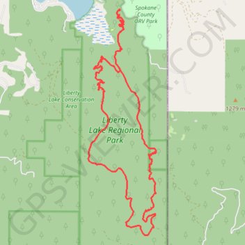
Liberty Lake Loop via Zephyr Connecter
Evening hike in Liberty Lake Regional Park
- Distance: 12.0 mi
- Elevation gain: 2,425 ft
- Maximum elevation: 3,691 ft
- Elevation loss: 2,421 ft
- Minimum elevation: 2,073 ft
- Moving time: 4 h 6 m
- Moving speed: 2.9 mph
- Maximum speed: 6.4 mph
- Total time: 5 h 15 m
- Global speed: 2.3 mph
Interactive trail map
Trail profile
- Distance: 12.0 mi
- Elevation gain: 2,425 ft
- Maximum elevation: 3,691 ft
- Elevation loss: 2,421 ft
- Minimum elevation: 2,073 ft
- Moving time: 4 h 6 m
- Moving speed: 2.9 mph
- Maximum speed: 6.4 mph
- Total time: 5 h 15 m
- Global speed: 2.3 mph
About this trail
Name: Liberty Lake Loop via Zephyr Connecter trail, distance, elevation, map, profile, GPS track
End: Zephyr Connector, Spokane County, Washington, United States (47.63548 -117.05563)
Coordinates: 47.58922 -117.06518 47.63575 -117.04446
Topography: Spokane County topographic map, elevation, terrain